Phantom Ranch

Phantom Ranch is an exclusive place that I have been hearing about for years and have always wanted to visit. Exclusive it is, because there is a quota on how many people can get reservations there or in the campground in a season. There are no other places to stay in the canyon, except for hikers who have back country permits to pitch a tent elsewhere. There is a lottery reservation system and it has a 13 month advance timing. If you are randomly chosen and your requested dates fit open accommodations, you get to stay. If not, you start over.  This one of the reasons why only 1% of the millions of visitors to the canyon in a year will get to stay at Phantom Ranch.

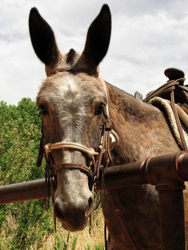
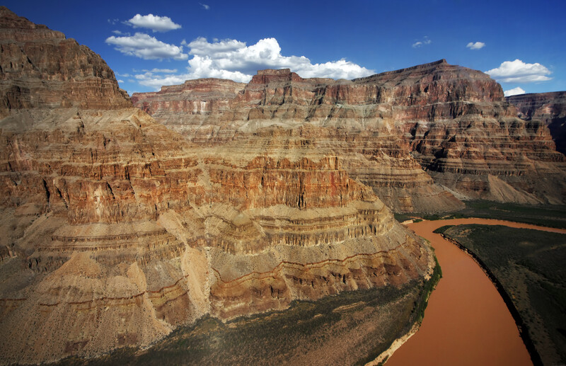
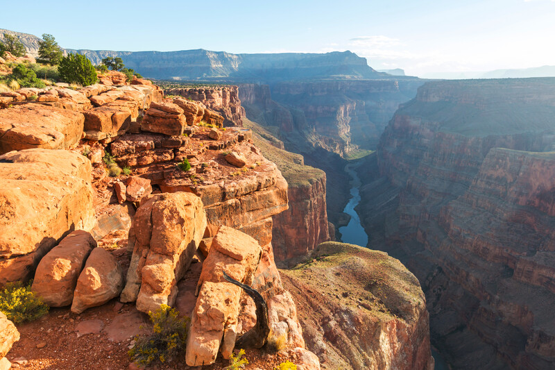
The ranch is at the bottom of the canyon at the intersection of the Bright Angel Trail, the Kaibab Trail North and South, and the Colorado River. The buildings were designed by Mary Elizabeth Jane Colter (what happens when your parents can’t decide what to name you) and built in the early days of tourism to the canyon. They are really beautiful stone and timber buildings that almost disappear into the surroundings. When the designs were approved the plan was to name the buildings Roosevelt Chalets but Ms. Colter said “not if you want to use my design”. She had already named it Phantom Ranch and that’s what it stayed. The rich and famous rode mules down the trail and stayed there, sometimes for weeks. There are cabins housing from 2 to 10 people, and 2 dormitories for males and 2 dormitories for females. Dorms have five bunk beds each and a common shower and restroom.

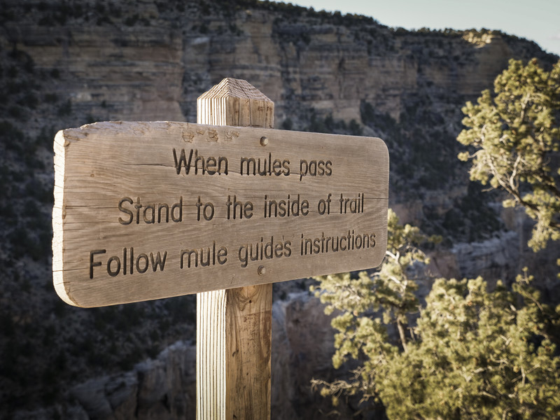
Meals are served at the Ranch by reservation also. They are rather expensive but that is understandable when you realize that almost everything that comes and goes to the ranch has to do it by mule. Breakfast goes for about $24 and the early seating is at 5:30 am. If you like to sleep in you can catch the late seating at 6:30 am (hmm…). My food will be carried in my pack to the campground by mule so I have no reservations for a meal at the canteen, but I may stop in to buy a postcard or a drink while I’m there.

Bright Angel Campground where I will be tenting for two nights is only a short walk from Phantom Ranch. On this “in between” day we will be doing some day hiking along the river and some side canyons. I’ve heard this is supposed to keep us from getting stiff and sore before the hike back up to the rim again. We’ll see.

Approach to Phantom Ranch

The Park Service has a lovely video of Phantom Ranch and detailed instructions for the lottery reservation system at http://www.grandcanyonlodges.com/lodging/phantom-ranch/

Photos from canstock.com

Oh, What Shall I Wear?

Oh, what shall I wear (that doesn’t make me look like a dork)?

I have photos of all my most memorable hikes. Most of them were taken by me so I am not in them (before selfies) but the ones I am in are always a little embarrassing. Some people look really cool when they’re hiking (and that is SO important) but me, not so much. I just don’t look like I know what I’m doing.

This hike might be different, although I’m not going to bet on it. I’ve had time to prepare and get some real hiking clothes. I justify it more on the practical side so I don’t appear totally vain and superficial. The right hiking clothes do make a difference in comfort, and I have listened to people talk about comfort a lot.

I’ve already shown you about the weather extremes that are possible in May (in post E) so you know that layering on top is going to be important. I also value things that breathe, dry quickly, and are stretchy to allow me to move. I love pants with good pockets, that will not look dirty even if I wear them all three days, and are somewhat water resistant. With these things in mind here is my list.

  • 2 short sleeve T shirts
  • 1 long sleeve T shirt
  • 1 fleece pullover
  • 1 rain jacket (which I might leave behind if the forecast is for no rain)
  • 1 pair convertible pants/shorts
  • 1 pair long pants
  • Socks and underwear
  • Brimmed hat and bandanna
  • Warm hat and gloves

I already wrote about my hiking boots and socks, but I’ll also take along a pair of lightweight camp shoes to give my boots a rest at night.

Actually, I am going to look like a dork on this hike too, because I found this awesome hat that I can also wear all summer in Wisconsin. It will keep the giant mosquitoes and deer flies off my head because it has a bug net that I can lower for ultimate protection.

Front and back selfie – my awesome bug hat.

Another useful purchase for this hike was a set of gaiters. These attach to my boots and come up to my knee to keep my pants and legs clean and dry, and keep debris out of my boots. They are easy to put on and comfortable to wear. I’ve already tried them out – they are good in the snow, an added bonus.

Gaiters

So, what do you think? Am I ready? (ready to look “not cool” in this year’s pictures too?)

Nourishment

A to Z Blogging Challenge, the letter N

(Because we have to eat…)

Eating is a part of hiking that has always interested me. (Actually, isn’t eating a part of almost everything, and what’s not to like about that?) It is challenging to plan for a time when physical demands on the body are great and food is… well, scarce.  On this hike, we will have to pack our meals and snacks for three days, carry fuel and gear to cook the food, and make sure we leave no packaging behind. Some of the food needs to be accessible on the trail as we walk. And, of course, we need to carry enough water for drinking as well as cooking. Here’s our plan.

My brother has some “rations”, dried meals, that he wants to use for the nights when we will be in camp. These will be simple, just add hot water and stir, meals that are designed to be high in calories and electrolytes. We know we will be hungrier than usual and the recommendation is to increase our calorie intake by half – 3,000 calories per day at least.  Other than these two evening meals I don’t plan to have to heat anything – that will mean less fuel to carry and less time spent cooking.

Dried or dehydrated meals are really great because they are light.  Our guidelines say our food for the day should only weigh between 1 and 1.5 pounds. If it’s heavier than that, it isn’t the right food.  

The noon meals while hiking will be short stops, so I want to take tuna or chicken in foil packs, and some kind of cracker. We will also be snacking on trail mix, nuts, Kind bars, and dried fruit. I tend to like salty foods rather than sweet while hiking because I know I need the electrolytes. Sodium is especially important to avoid dehydration (see my D post for more on that). Another way I’m going to watch my electrolyte balance is by putting powder Gatorade or similar drink mix in my water.  The flavor helps me drink more of it too.

packaged trail mix
Jumbo bag to be split up into zip-locks and carried for snacks on the go.

Other than the foil packs for the dried meals and the tuna/chicken meals, I want to repackage my snacks in zip-locks so I don’t have wrappers to dispose of. I can use the zip-locks to hold whatever trash I do have to haul out. 

Our food guidelines included a few other tips such as:

  • Include some spicy sauces to add to bland foods like rice or instant dried beans
  • Hot cereals are great for breakfast if you have time to boil water
  • Dry instant milk, dried meat like turkey or beef jerky are other dehydrated foods that work well
  • Granola gives some crunchy variety to breakfast or snacks
  • Avoid anything in a can – heavy and you have to carry it out too
  • Avoid fresh fruit that will get bruised, or affected by the heat

Just thinking about all this dried stuff makes me hungry and thirsty for fresh vegetables and fruit and something cold to drink. And that brings me to the final part of the hiking experience that I look forward to – the meal after the return to civilization.  Deprivation heightens appreciation, just sayin’…

Mules…

Thank you, Mule.

I’ve mentioned already that this hike, sponsored by the Grand Canyon Association Field Institute, is titled “Take a Load Off: Mule Assisted Camping 0514”.  My brother was being thoughtful of me and his wife, thinking that we would be better off having assistance from some friendly mules. The mules have agreed to carry a duffel bag for each of us which will lighten our load considerably.

On our first day we will meet at about 10 am to have our equipment checked over by our guide, and then our tenting equipment, some of our food and clothing – basically anything we don’t need on the descent – will be packed in the bag allowed us. I think our mule train will start that afternoon. I’m guessing they will go down the Bright Angel Trail, cross the Colorado on the Black Bridge and stay the night at Phantom Ranch (see this pic of mules crossing scary bridge). Almost everything that goes to Phantom Ranch goes by mule, including supplies for the canteen meals and goods sold in the store. Duffel transport is a common expense for hikers, especially ones going up who don’t want all that stuff on their own backs.

A lot of people ride the mules to Phantom Ranch too but the park video says the people getting off the mules are just as tired and sore as the ones who hiked the trail. Excuse me for laughing, haha. When you don’t ride for hours at a time as a regular thing, that is exactly what happens.  

Our hike guidelines give specific instructions to hikers who might happen to meet a mule train on the trail. We are to back up against the uphill side of the trail and wait quietly until the last mule has passed and is at least 50 feet away. Although the mules are well trained and mostly stick to business, if they are harassed or startled it can result in an accident. It is a real shame when a mule is lost off the trail, as you can imagine. And worse yet if a hiker falls, which is why we are given the uphill side. Lucky us.

Book Cover for Brighty of the Grand Canyon

Mules have a real history in the Canyon. An old children’s book which I read to my children years ago was “Brighty of the Grand Canyon”. It was kind of a history lesson of the prospecting days, when miners traveled the canyon looking for gold, with a mule carrying their provisions. Brighty, the mule, is the star of the book – kind of the Black Beauty of the mule world.  A great book about the canyon, and not just for kids. I loved it. Earlier this month a reader reminded me of this story that she had also read and loved. I’m not sure but I think Brighty might have been a burro (small donkey), which is different from a mule, but close enough for these purposes.

The little corral at Phantom Ranch looks just the same as it did when first constructed in the 1920’s. I’m hoping to hang out there a little and talk to some of the handlers because I’m curious about where the mules come from and how they are trained. I know they are very reliable and sure footed, which makes them a good fit for terrain in the canyon.

Layer Cake Geology

Geology has never been a compelling subject in my world. I would just as soon leave it to those who find it fascinating – like my niece Jamie who is a geologist. But I have to say that the Grand Canyon is a very unusual, actually singular, place when it comes to geology. The rock layers are found in chronological order, the youngest on top with evidence of past marine life, and the oldest, Vishnu schist, on the bottom with no evidence of life in it. Every kind of formation you can imagine can be found there: mesas, buttes, temples, platforms, castles, terraces, massive walls, amphitheatres, canyons, ridges…

As the Colorado River cut down through the earth it exposed layer after layer of deposited soil and rock. Because the layers were of different kinds of rock, they are different colors, different hardness and different levels of stability. The scenes in the canyon are like looking at a record of time, laid open on the walls of the canyons. The layers match on both sides of the river which proves that it was the process of erosion over time that caused the chasm. The plateaus on either side of the river were once continuous.

Science estimates it has taken 1.2 billion years to erode through all those layers and countless numbers of people, scientists, geologists have been left speechless looking at the grand scale of it all.

That’s all for L.  Short and sweet, but lots of pictures.

Even looks kind of like a layer cake…

scene at Grand Canyon National Park

Photos from canstockphoto.com

Kaibab

I have just been looking at the Grand Canyon on Google Earth. From a distance I could not tell what I was seeing. It was the crooked line of a river made broad by lighter borders unevenly stretching out on either side. Zooming in closer I suddenly saw height and depth. The dark areas were shadow of high cliffs. The light areas were less steep slopes with sparse vegetation. The trails were white lines zig zagging down the descents and they went on and on, seemingly forever, as I followed the route our hike will take.

Google Earth is a unique way of seeing the Canyon – vertically, looking straight down. Although it doesn’t compare to actually being there, it gives a dramatic view of how large and complicated the formations are. Look at it if you can.

I always have a hard time understanding the lay of land from written descriptions but I’m going to try to describe this larger area, and show you where Kaibab fits in. Stick with me here.

A high, mountainous plateau goes from east to west across the northern edge of Arizona. It is bisected by the Colorado as it winds it’s way southwest. It’s hard to believe that the river made such a wide, dramatic gash through the plateau that slopes toward the south. On the north side of the river, from east to west, lie the Kaibab, the Kanab, the Uinkaret and the Shivwits Plateaus. On the south side of the river there is the Coconino Plateau and the Hualapai Plateau.  Hundreds of tributaries run down into the Colorado, cutting their own canyons as they go, especially from the north side.  

The Kaibab Plateau “is covered with a beautiful forest, and in the forest charming parks are found…. The plateau has four months of the sweetest summer man has ever  known.” John Wesley Powell

As far as the word Kaibab itself, well, there doesn’t seem to be a known meaning of it on the internet. It is probably a Paiute Native American word and it’s attached to many things in the Grand Canyon area. There is the Kaibab National Forest, which is home to a herd of large antlered deer (well fed and well managed), there is the Kaibab squirrel which is nearly extinct but still holding on, there is the large Kaibab Plateau north of the canyon and, of course, the Kaibab Trail with its South and North branches. Our descent will be on the South Kaibab Trail, and that is for another post.

map of Grand Canyon National Park

Don’t forget to check out the Grand Canyon on Google Earth. It’s amazing!

Journey

The Journey, Getting There from Here

Although I haven’t taken this Grand Canyon hike yet, I have had to figure out how to get there. I did this quite some time ago to make sure that my reservations were in place.  For me, the hike itself was quite an investment and I didn’t want to risk not being there at the right time.

Driving by land is an obvious good choice. My brother and his wife who live about three hours from me, in Wisconsin, are driving and have room in their vehicle for all our equipment.  I am flying out and meeting them before the hike and will be traveling light. Since there are many great places to visit between Wisconsin and Arizona, including many national parks, my brother will be taking his time and may do some other shorter hikes on the way.

Flying into the Grand Canyon area usually means going to one of the nearby cities with an airport – Flagstaff, Phoenix or Las Vegas. Although there is a small airport in Grand Canyon Village, service there is  limited to private and charter flights. From the cities, car rental is the advisable travel means. My brother’s approach will be from the east which meant that Flagstaff was the most logical choice for me. It is, more or less, on his way to the canyon. We will meet in Flagstaff and drive to Grand Canyon Village the day before our trip starts.

Did I make it easy enough to see where the cities with airports are?

Our first day of the hike requires us to be present at 10 am, so we have arranged lodging in Grand Canyon Village on the South Rim within the National Park. It is a small village and has limited year-round lodging. There are a dozen or more hotels including Bright Angel Lodge, El Tovar Hotel, Kachina Lodge, Thunderbird Lodge, the Motor Lodge and Yavapai Lodge. These hotels have been hosting visitors since the park became a tourist destination and several of them are quite famous. El Tovar is right on the Rim and built like a European castle!  Lodging is also available on the North Rim and at Phantom Ranch inside the canyon, which I will mention in a future post.

My brother was able to get a hotel room, but I was not. Instead, I have reservations at Mather Campground in Grand Canyon Village. I will be tenting the night of our arrival, the first night of the hike before the descent, the two nights at Phantom Ranch, and the night after we return to the South Rim. Hopefully, I can survive five nights of sleeping on the ground.

My airport nearest my home is 240 miles away in Minneapolis so I have transportation complications on that end as well. I will probably travel there the night before the flight and do a park and fly stay at a motel. Living in the wild of northern Wisconsin has its aggravations…

There is so much more that I could say about getting to the various destinations in the Grand Canyon. I didn’t even mention much about the North Rim or the West Rim. It’s a big place.

Indians

Indians or Native Peoples of the Grand Canyon area

My first visit to a pueblo was several years ago at Mesa Verde in Arizona.  Pueblos are multi-room dwellings made of clay and the ones at Mesa Verde were built in the clefts of a canyon wall. The native people who lived there were most likely Anasazi, who left the area in the 1300’s A.D. during years of drought. They vanished, leaving behind these remarkable dwellings. They were named Anasazi, or Ancient Ones by the Navajo people north of the canyon.  It is an amazing place to visit.

There were different tribes of the pueblo peoples who inhabited the Grand Canyon, most of whom were semi-nomadic farmers and hunter gatherers. They traveled back and forth from rim to lower canyon to rim, depending on the season. Many of their trails are still present and used by visitors. Indian Gardens is a campground on the Bright Angel Trail but was once an area farmed by the Havasupai tribe.

Presently, one place to experience Native American culture is on the Havasupai Reservation in Havasu Canyon. That is one part of the canyon that my brother has not visited yet and still hopes to. We tried to get reservations to visit there last year but could not. The Havasupai have their own tourist bureaus and quotas of visitors. I love what their name means – “people of the blue-green water”.  They and the Walapai tribe (“people of the pine tree”) live in the western region of the South Rim.

The Grand Canyon Skywalk, on what is called the West Rim of the canyon, is actually on the Hualapai Reservation and outside of Grand Canyon National Park. It is an amazing cantilever bridge, out from the cliff in a horseshoe shape, and 4000 feet above the canyon floor.  Add to that a glass walkway and you have a real tourist attraction.  I have seen pictures of people who became paralyzed with anxiety as they looked down and had to be carried off the walkway. 

There is a lot of controversy within the Hualapai tribe and outside of the tribe concerning this bridge. There are people on the environmentalist side who aren’t sure it’s a good way to preserve the canyon. There are others on the practical side who feel the bridge is a way to raise money for serious needs of the tribe. It’s complicated.

The Hopi people live in the eastern section of the South Rim, and to the southeast are the Zuni tribes. North of the canyon is the Paiute Reservation in the west and the Navajo Reservation in the east. The Navajo were latecomers to the region and lived in the canyon itself only in the 1860’s when being pursued by the U.S. Cavalry. In addition to farming and herding, many of the tribes are craftsmen/women in cloth weaving, basketry, pottery and jewelry making.  You’ve probably heard of Navajo blankets and rugs, right?

Birthday to Remember

April 8th, My Birthday 2019

Do you remember any of your birthdays? How you celebrated? A special gift you received? Someone who surprised you with a visit or a greeting of some kind?

I try to have something memorable happen on my birthday most every year, and I’m willing to come up with it and do it alone if no one is available.  This year I didn’t have to do it alone. My mom and I did something together. We got sick.

Food poisoning, but we can’t figure out what it was for sure. I spent the day barely able to move without passing out.  In spite of being very dehydrated, neither of us wanted to risk putting food or drink into our unstable stomachs.  I spent the day crawling from the bed to the recliner and back again. I cancelled the one appointment for the day – the gym – since there was no energy available for training.  In short, it was not the memorable event I had in mind.  I get a rain check, right?

Today is better. We are both on our feet a little more, but still glad not to have a lot to do today. It is amazing how dependent we are on vital elements, like water. Take away ten pounds of water weight, and I’m barely able to function.  It definitely reminds me of my episode of dehydration on the Appalachian Trail and the recent D post I wrote on dehydration. 

It all makes me think of how we are designed, with enough flexibility to cover the usual ups and downs of life. Most of the time we don’t have to think about how much we’ve eaten or not eaten, or whether we’ve had enough to drink. Food and beverage are available to us on a pretty regular basis, leaving us free to worry about lesser things.

But there are places in this world where it is not so.  What must it feel like to live in a body that is little more than skin and bones, where there is no food or water to be had?  It happens in our own country, where being homeless or in poverty can make it so difficult to be fed with something nutritious.  I was overcome with weakness, loss of motivation, pain and the need to rest somewhere safe.  I can’t imagine being out on the street in a city, or out in a desert village in Africa and trying to survive under those conditions.

I am grateful that I was at home yesterday, recovering slowly as I watched birthday greetings come in on Facebook. I got a delivery of flowers, several cards and a book I had ordered in the mail, a visit from my brother and his kind delivery of some Pedialyte.  I have reasons to remember this birthday, just sayin’…

Hiking Boots

A number of years ago I trained for and participated in a 60 mile walk over three days.  From the first days of training there was emphasis on what we were to wear on our feet. Your shoes will make or break your walk, they told us.

One of our training meetings was held at a retail outlet for a major athletic shoe company. I won my first pair of expensive, properly fitted hiking shoes. To be honest, I didn’t understand what people were talking about when they said their perfectly good appearing shoes had worn out. I wore all my shoes until the soles came off or holes appeared.

That hike taught me how important foot protection is when walking long distances. I had some major blisters. Some people lost their toenails, and others had to drop out of the walk with other foot problems. I made it to the end, but it was challenging.

I have two pair of hiking shoes now, low ones and ankle high ones. I’ve had them for over a year and both pair are pretty well broken in.  I know how they feel and how they perform. I’m not sure which pair I will take to the Grand Canyon, but it will probably be the ankle boots, both for protection and stability.

Keene and Kuru – I probably should have used these for letter K

The steep grade on the descent requires shoes with plenty of room in the toe. With every step I’ll be sliding forward slightly and I don’t want my toes rubbing against the toe of the shoe. I’ve seen the recommendation of finding a shoe that’s comfortable and then buying one half size larger. I didn’t do that with my ankle boots, but I’m hoping with the extra lacing up over my ankle that my foot won’t slide much, if at all. These boots also have a thick sole, water resistant qualities and some breathability. Sometimes I wear them for everyday wear just because they are very comfortable.

I’ve also invested in thin, wool hiking socks that don’t bag or bunch up. They are padded and wick moisture away from my feet. (Cotton absorbs moisture, stretches out, and can chafe, so no cotton.) Guidelines for the hike suggest a thin, polypropylene sock as a liner underneath the wool sock but I haven’t found those yet. The most irritating sock problem is that pair that slides down, step by step, and disappears into my shoe. I’m testing all socks to make sure that doesn’t happen.

Another foot saving precaution I’m going to take is to carry certain items in my first aid kit. I’m taking moleskin to cover any blister that appears. I’m taking a product called Body Glide which is great to prevent chafing anywhere it occurs.

Good stuff to have on a hike.