
Distances in the Grand Canyon are described in various ways by those who have hiked them frequently. There are straight line miles, “as the crow flies” miles, and the miles spent zigging and zagging, as Colin Fletcher called it. From “The Man Who Walked Through Time”,
“Cross-country on foot, miles are always misleading: the hours are what count. In the Canyon, miles become virtually meaningless. From start to finish of my journey I would cover, in a straight line, only forty-three. The river mileage came to one hundred and four. When I ran the map measurer from one end to the other of my proposed route, carefully following each winding contour, it registered just two hundred. But I felt sure, and Harvey Butchart greed, that I would walk at least four hundred miles as the foot slogs. And there were times when I would be lucky to travel half a mile in an hour.”
Another word, switchback, is often used to describe hiking trails and roads that go up or down steep hills. The trail will go in one direction up the hill, turn 180 degrees and continue uphill in the opposite direction, and repeat until the hill is climbed. The main purpose of this zigzag process is to protect the hill, and the trail from erosion. It is also a way of controlling the grade for ease of hiking, although it makes the distance considerably longer.
Almost every place I’ve hiked has been in hilly or mountainous terrain. Often there are switchbacks and there will also be signs to stay on the trail and not take shortcuts. Shortcuts that go straight down the hill will get worn down and become a path for rainwater to follow, producing erosion and eventually the trail will be ruined. It’s tempting at times but I’ve learned not to take those shortcuts.
The descent into the canyon includes so much vertical distance in such a short space that there will be a lot of zigzagging, especially on the South Kaibab. The picture below is of a section of the Bright Angel Trail, the upper left corner and lower right corner have a lot of visible switchbacks. Looking at this picture makes me think this is going to be a long, grueling climb. What fun! I can’t wait. The word zigzag is interesting because of the z’s which sort of mimic the shape of a switchback.
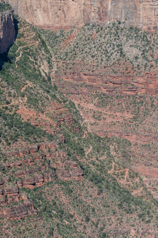
photo from canstock.com by Kelly Vandellen
We are at the end of the alphabet once again. The A to Z is a valuable writing experience for me, but more than that, it is a joy to meet others in this online blogging community. I am always amazed at the creativity, the sharing of comments and encouragement, the friendship extended, and the way it is all shared through the written word. Thank you to everyone who read and commented, and to the organizers of the A to Z. It has become my April habit.

I have loved hiking. You’ve never hiked a level trail? I spent 12 years in southern Delaware and it is flat. The State Parks have some fun trails, but very low terrain. My husband and I visited Moab and had a great time hiking all over.
Glad to have found you, at that tail end of AtoZ!
Doesn’t Speak Klingon
I think I wrote “most” not all. I lived and hiked in Florida for 30 years so i do know flat, for sure. Going back to check your blog. Thanks for coming by!
No kidding, Terrains like this includes a lot of zig zagging. In the olden days when we were geocaching with just a straight arrow GPS we’d often end up in front of a huge wall, knowing the treasure was literally a few feet away – just *beyond* the wall. Uuuggghhh.
Congrats on completing A-Z! i’ts been fun following you!
https://thethreegerbers.blogspot.com/2019/04/under-arrest-z-is-for-ziggy-zailo-family.html
You geocache too! Fun.
Great A2Z journey. I enjoyed joining you, virtually.
And I enjoyed you being along, virtually. Thank you so much!
I have enjoyed your posts about your Grand Canyon prep and I look forward to hearing about the actual hike when you write about it.
The anticipation is building… I can hardly believe it’s only two weeks away. Thank you so much for reading along, and I will be sure to add more after the hike.